Nepal Disaster Update Live coverage

Live coverage

What caused the Rasuwa flood

Local rainfall is ruled out, and the US Geological Survey has reassessed the tremor recorded minutes earlier as a glacial collapse rather than an earthquake. Here is what the evidence supports, how strongly, and why the answer changes what people downstream should do.

Status: not confirmed

No government has issued a confirmed cause for this flood. What follows is what the available evidence supports, and how strongly. Where something is a working hypothesis, it says so.

What is ruled out: local rainfall

Meteorologists have ruled out heavy local rainfall in Rasuwa as the cause. A monsoon flood builds with the rain that causes it; this one arrived without it. Satellite data did show rainfall on the Tibetan side of the border, which may have contributed to conditions upstream, but it does not account for a surge of this size arriving this fast. That single fact is what sent investigators upstream, and across the border, in the first place.

The explanations under examination

An ice-and-rock avalanche dammed the Lhende Khola, and the dam then burst

Leading explanation

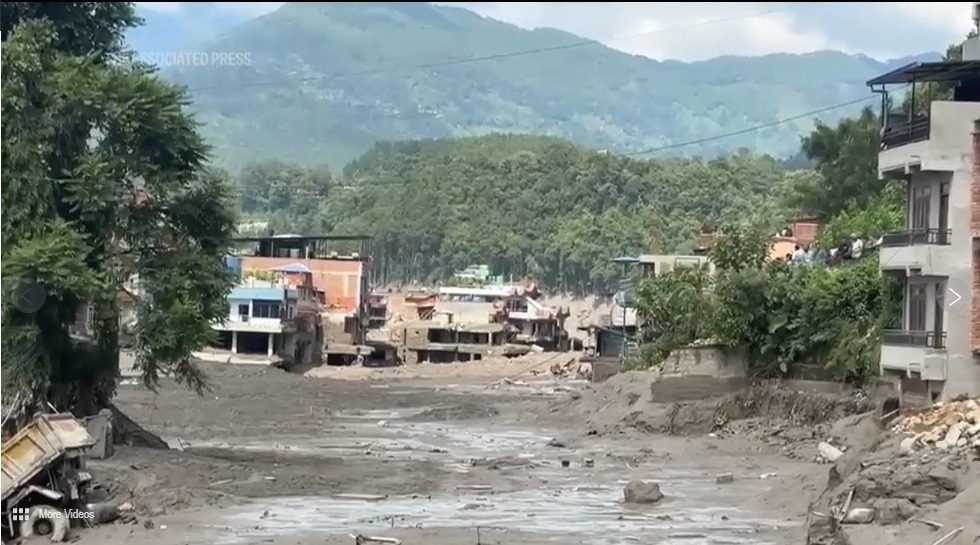
Nepal’s Department of Hydrology and Meteorology and independent glaciologists, working from satellite imagery shared by Chinese counterparts through ICIMOD, put forward a preliminary hypothesis: an ice-and-rock avalanche blocked the Lhende Khola, a Bhote Koshi tributary on the Nepal-China border, roughly 20 km upstream of the Miteri Bridge. That formed a temporary debris-dammed lake, which then burst. This is described as preliminary, and no government has confirmed it.

The 08:37 seismic signal was a glacial collapse, not an earthquake

Reassessed

The US Geological Survey initially logged a magnitude 4.4 earthquake at 08:37 local time, minutes before the flood. It has since revised that analysis and concluded the signal was in fact a magnitude 5.2 glacial collapse rather than a tectonic earthquake, based on nearby seismic stations, long-period seismic waves and satellite imagery. In other words the tremor was not a separate trigger; it was the collapse itself being recorded.

Glacial lake drainage on the same river before

Related hazard

A broadly similar flood on the same river in July 2025 was ultimately attributed to the drainage of a supraglacial lake, meltwater pooled on the surface of a glacier. ICIMOD scientists say cascading glacial hazards of this kind are increasing at an "unprecedented" pace across the Hindu Kush Himalaya.

Ordinary monsoon rainfall in Rasuwa

Ruled out

Meteorologists have ruled out heavy local rainfall in Rasuwa itself as the cause, while noting that satellite data showed rainfall on the Tibetan side of the border. Rainfall alone does not explain a surge of this size arriving this fast, which is what pointed investigators upstream and across the border in the first place.

Why the distinction matters downstream

This is not an academic question. Each explanation implies something different about what happens next:

  • A landslide dam can re-form. Debris that blocked a river once can block it again, and the material is already sitting in the valley. That is precisely what has now happened: China’s Ministry of Water Resources reports a new barrier lake near the confluence of the Chhochen Khola and the Purepu Tsangpo, holding around 2 million cubic metres of water by the morning of 27 August, and Chinese state media warn it could break. Both rivers feed the Trishuli system, so a release would run down the same corridor.
  • A drained glacial lake is spent, but the same conditions exist at other lakes in the same range, several of them unmonitored because they sit across the border.
  • If seismic shaking had been the trigger, every unstable slope and moraine in the area would have to be reassessed for aftershock risk. The USGS reassessment makes that less relevant here: the signal was the collapse, not a quake that caused it.

The standing warning to stay off the banks of the Bhote Koshi, the Trishuli and the Narayani reflects the first of these. Downstream in India, authorities in Bihar have opened the Valmikinagar Barrage on the Gandak as a precaution and prepared to move 10,000 to 12,000 people.

The monitoring gap

The catchment above the Rasuwagadhi crossing is inside Tibet. Nepal has no gauge, no siren and no camera up there, so the first indication of a problem on the Nepali side is the river itself. What warning did come this time came from Chinese satellite imagery shared through ICIMOD, after the event and not before it. Downstream, most of the gauges that did exist on the Bhote Koshi and Trishuli were destroyed by the first wave, which means any second surge would come with less notice than the first.

Nepal classifies more than 20 of its own glacial lakes as potentially dangerous. Several have sensors and sirens. Most of the lakes and moraines that feed Nepal’s northern rivers do not, and a share of them are not in Nepal at all.

It has happened here before

A broadly similar flood struck the same river in July 2025, and was ultimately attributed to the drainage of a supraglacial lake, meltwater pooled on the surface of a glacier. Hydropower infrastructure on this corridor has now been hit twice in thirteen months. ICIMOD scientists say cascading glacial hazards of this kind are increasing at an "unprecedented" pace across the Hindu Kush Himalaya, as ice retreats faster than it is replaced and more meltwater collects behind weaker walls in valleys where more people now live and build than a generation ago.

Questions people are asking

What is a glacial lake outburst flood (GLOF)?

High in the mountains, retreating glaciers leave lakes behind. The wall holding one back is often just loose rock, gravel and buried ice rather than solid bedrock. When that wall fails, the whole lake leaves at once and travels down the valley as a mix of water, mud and boulders. It needs no rain and no warning, which is what makes it so dangerous.

Was the Rasuwa flood a GLOF?

Not in the strict sense, on current evidence. The leading explanation is an ice-and-rock avalanche that blocked the Lhende Khola and formed a temporary debris-dammed lake, which then burst. That is a landslide-dam outburst rather than the failure of a pre-existing glacial lake. The two are closely related hazards and produce the same downstream signature, which is why the distinction took time to establish. A broadly similar flood on the same river in July 2025 was attributed to glacial lake drainage.

Did an earthquake cause the Nepal flood?

No. The US Geological Survey initially logged a magnitude 4.4 earthquake at 08:37, minutes before the flood, but has since revised that analysis: the signal was a magnitude 5.2 glacial collapse, not a tectonic earthquake. It was the collapse being recorded, not a separate trigger.

Could it happen again in the same valley?

Yes, and officials say the immediate risk has not passed: China’s Ministry of Water Resources reports a new barrier lake forming upstream inside Tibet holding around 2 million cubic metres of water, and warns it could break. Beyond this event, a broadly similar flood struck the same river in July 2025, and ICIMOD scientists say cascading glacial hazards are increasing at an "unprecedented" pace across the Hindu Kush Himalaya.

Sources