Nepal Disaster Update Live coverage

Live coverageनेपालीमा पढ्नुहोस्

Rasuwa flood, 2026

A flash flood came down the Bhote Koshi from Tibet into Rasuwa on 26 August 2026. This is what is confirmed, what is still unknown, and who to call.

In danger right now?

Call 100 (Nepal Police) or 112 from any mobile. Do not wait for anything on this page to load.

Full list of Nepal emergency numbers, and what each one is for

Where the numbers stand

289confirmed dead in NepalNepal Police, 27 August 2026, 2:30 pm NPT
826listed missing in NepalNepal Police, 27 August 2026, 8:15 am NPT
558missing on the China sideCCTV, Gyirong Port
73injuredNDRRMA and Nepal Police
113rescued so farNDRRMA, 27 Aug
14hydropower projects damaged, about 748 MWNepal Electricity Authority
Rs 200 billionroad and bridge damage, preliminaryMinister Sunil Lamsal, 26 Aug
Rs 1 billionrelief money releasedGovernment of Nepal

Read the two headline numbers against their own clocks. The death toll is from the Nepal Police bulletin of 27 August 2026, 2:30 pm NPT. The missing figure is from the earlier police bulletin of 27 August 2026, 8:15 am NPT. The newest bulletin gives a death toll and no missing count, so some of the 826 have since been confirmed among the dead. Damage and rescue figures come from the UN OCHA situation overview, 27 August. Every count here is provisional and moves in both directions.

A second flood is still possible: a new lake has formed upstream

China’s Ministry of Water Resources reports that a barrier lake, a river blocked by debris into an artificial lake, has formed near the confluence of the Chhochen Khola and the Purepu Tsangpo, inside Tibet close to the Nepal border. Chinese state media put the volume behind it at around 2 million cubic metres by the morning of 27 August, and warn it could break.

Both rivers are upper tributaries of the Trishuli system, so a release would run down the same corridor the 26 August flood took. Most river gauges on the Bhote Koshi and Trishuli were destroyed in the first wave, so a warning would come with less notice than normal.

Keep off the banks of the Bhote Koshi, the Trishuli and the Narayani until officials say it is clear. Downstream in India, authorities in Bihar have opened the Valmikinagar Barrage on the Gandak as a precaution and prepared to move 10,000 to 12,000 people.

Source: China’s Ministry of Water Resources, reported by CCTV and Global Times, reported 27 August 2026.

What happened

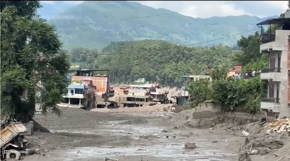
At about 09:00 Nepal time on 26 August 2026, the Bhote Koshi rose suddenly where it crosses into Nepal at Rasuwagadhi. It was not raining in the Rasuwa catchment. Within minutes the water was through Timure, the nearest Nepali settlement, taking nine bank branches and the customs post with it. Syabrubesi, downstream and the gateway to the Langtang trek, lost its helipad, which slowed rescue flights into the upper valley on the first day, when they mattered most. Around a dozen riverside settlements in northern Rasuwa were hit in that first hour.

The flood did not stop at the district line. The Bhote Koshi joins the Trishuli at Syabrubesi, and the Trishuli runs on into the Narayani. The surge moved through Betrawati and Trishuli Bazar in Nuwakot, Galchhi and Dhunge Bazaar in Dhading, and past Muglin. Bodies have since been recovered as far as Chitwan and Nawalparasi. The Armed Police Force alone recovered 121 from the Narayani by Thursday afternoon.

Counts rose sharply and repeatedly through the first two days as search teams reached areas that had been cut off. The Prime Minister’s Office reported 95 dead on Wednesday evening and NDRRMA 72; by Thursday morning the figure was 165, and by 27 August 2026, 2:30 pm NPT it was 289. Every figure on this page is provisional for that reason.

See the full hour-by-hour timeline.

The route the water took

From the suspected break-off point in Tibet down to the furthest reported damage in Nuwakot, a drop of roughly 4,500 metres.
PlaceElevationWhat happened
Glacial source area, Lende Khola headwaters
China (Tibet)
~5,000 mHigh above the Lende Khola on the Tibetan side. Satellite images reviewed by researchers suggest a mass of ice and rock broke away here first. There is no monitoring station upstream of this point on either side of the border.
Lende Khola blockage
China (Tibet)
~3,000 mThe ice and rock dammed the narrow valley, water built up behind the plug, and the plug then failed. That is the step that turned a landslide into a flood. About 20 km upstream of the Rasuwagadhi crossing. No rain was recorded nearby that morning.
Rasuwagadhi / Gyirong border crossing
Nepal-China border
~1,850 mThe China-Nepal crossing. The Lende Khola and the Kyirong Tsangpo meet here and become the Bhote Koshi. Customs and dry-port facilities were hit on both sides. China has confirmed three deaths near Gyirong.
Timure
Rasuwa, Nepal
~1,900 mA border market town, and the worst-hit settlement in Nepal. Nine bank branches and the customs post were swept away.
Syabrubesi
Rasuwa, Nepal
~1,470 mGateway town for the Langtang trek, and the point where the Bhote Koshi joins the Trishuli. The helipad was destroyed, which slowed rescue flights into the upper valley on the first day.
Betrawati
Rasuwa / Nuwakot boundary, Nepal
~730 mAbout 60 km downstream on the district boundary. By here the water had lost height but not force; the bridge and riverside settlements were hit.
Devighat
Nuwakot, Nepal
~460 mThe furthest downstream point where damage has been reported. Devighat Hydropower Station was hit. From the source area down to here is a drop of roughly 4,500 metres.

Open the interactive map of the flood path, with the coordinates for each point.

What may have caused it

No government has confirmed the cause. Ordinary rainfall is ruled out. It was not raining in the catchment that morning. These are the explanations under examination, ranked by how strongly they are currently supported:

  1. An ice-and-rock avalanche dammed the Lhende Khola, and the dam then burst (Leading explanation)
    Nepal’s Department of Hydrology and Meteorology and independent glaciologists, working from satellite imagery shared by Chinese counterparts through ICIMOD, put forward a preliminary hypothesis: an ice-and-rock avalanche blocked the Lhende Khola, a Bhote Koshi tributary on the Nepal-China border, roughly 20 km upstream of the Miteri Bridge. That formed a temporary debris-dammed lake, which then burst. This is described as preliminary, and no government has confirmed it.
  2. The 08:37 seismic signal was a glacial collapse, not an earthquake (Reassessed)
    The US Geological Survey initially logged a magnitude 4.4 earthquake at 08:37 local time, minutes before the flood. It has since revised that analysis and concluded the signal was in fact a magnitude 5.2 glacial collapse rather than a tectonic earthquake, based on nearby seismic stations, long-period seismic waves and satellite imagery. In other words the tremor was not a separate trigger; it was the collapse itself being recorded.
  3. Glacial lake drainage on the same river before (Related hazard)
    A broadly similar flood on the same river in July 2025 was ultimately attributed to the drainage of a supraglacial lake, meltwater pooled on the surface of a glacier. ICIMOD scientists say cascading glacial hazards of this kind are increasing at an "unprecedented" pace across the Hindu Kush Himalaya.

Read the full explanation of what caused the flood, including what a GLOF is and why the distinction matters for the districts downstream.

Damage

The Nepal Electricity Authority reports 14 hydropower projects damaged along the corridor, with a combined capacity of about 748 MW: 9 operating plants (354 MW) and 5 under construction (394 MW). The Department of Roads confirms the entire 42 km road from Betrawati to the Rasuwagadhi crossing was destroyed at multiple points, including several concrete bridges, cutting Nepal’s main overland trade and pilgrimage route to Tibet.

Physical Infrastructure Minister Sunil Lamsal put road and bridge damage alone at about Rs 200 billion on 26 August, and called the figure preliminary. Hydropower and private property are not in it.

See the full damage assessment, project by project.

Who is missing, and what that number means

Nepal Police listed 826 people missing in their 27 August 2026, 8:15 am NPT bulletin. That figure is a contact list, not a casualty list: phone lines, power and internet are down across the valley and are coming back slowly, so being out of contact does not mean dead. It is also older than the death toll above, so some of these 826 are among the 289 since confirmed dead. Nepal Police have not published a revised missing figure alongside the newer toll.

Nepal Police breakdown, 27 August 2026, 8:15 am NPT.
GroupListed missing
Travellers (466 foreign nationals, 113 Nepalis)579
Rasuwa residents161
Nepali Army personnel44
Nepal Police personnel28
Armed Police Force personnel13
Nuwakot residents1

Most of the missing foreign travellers were moving toward the Kailash Mansarovar pilgrimage route through Tibet. Chinese state media separately report 558 people missing around Gyirong Port on the Tibet side, 260 of them foreign nationals.

How to report someone missing, including the cross-border and foreign-national routes.

Common questions about the Rasuwa flood

What happened in Rasuwa, Nepal?

On the morning of 26 August 2026 a flash flood came down the Bhote Koshi river from the Tibet side of the border into Rasuwa district. Timure, Syabrubesi, the Rasuwagadhi border crossing and around a dozen riverside settlements took the heaviest impact, and the water carried on down the Trishuli into the Narayani. 14 hydropower projects were damaged. As of 27 August 2026, 2:30 pm NPT, Nepal Police confirm 289 dead in Nepal.

What caused the Nepal flood of August 2026?

No government has confirmed a cause. The leading explanation, from Nepal’s Department of Hydrology and Meteorology and independent glaciologists working with satellite imagery shared through ICIMOD, is an ice-and-rock avalanche that blocked the Lhende Khola inside Tibet about 20 km upstream of the Miteri Bridge, forming a temporary debris-dammed lake that then burst. The seismic signal recorded minutes earlier, first logged by the USGS as a magnitude 4.4 earthquake, has since been reassessed as a magnitude 5.2 glacial collapse rather than a tectonic quake. Heavy local rainfall in Rasuwa is ruled out.

Which districts of Nepal were affected?

Rasuwa took the first and heaviest impact, especially Timure, Syabrubesi and the Rasuwagadhi border crossing. The surge then moved through Betrawati and Trishuli Bazar in Nuwakot, Galchhi and Dhunge Bazaar in Dhading, and past Muglin into the Narayani. Bodies have been recovered in Chitwan, Nawalparasi East and West, Gorkha and Tanahun as well. Three deaths are confirmed on the Chinese side near Gyirong.

Is Kathmandu affected by the Rasuwa flood?

Kathmandu itself was not flooded. The damage runs along the Bhote Koshi and Trishuli valleys in Rasuwa and Nuwakot, north-west of the capital. Road links to the Chinese border through Rasuwagadhi have been badly disrupted.

How many people are still missing?

Nepal Police listed 826 people missing in Nepal in their bulletin of 27 August 2026, 8:15 am NPT: 579 travellers (466 of them foreign nationals), 161 Rasuwa residents, 85 security personnel and one Nuwakot resident. Chinese state media separately report 558 missing around Gyirong Port on the Tibet side, 260 of them foreign nationals. Combined, that is more than 1,300 people unaccounted for, though the two countries’ counts of foreign nationals may overlap. Out of contact does not mean dead. Phone lines, power and internet are down across the valley.

Is it safe to travel to Langtang or Syabrubesi now?

Syabrubesi is the main gateway to the Langtang trek and was directly hit, including the loss of its helipad. Roads along the river valley are damaged and a second surge has not been ruled out. Check with Nepal Police, the Tourist Police on 1144, and your trekking operator before travelling.

How can I donate to Rasuwa flood relief?

The Government of Nepal’s own channel is the Prime Minister’s Natural Disaster Relief Fund, run by the Office of the Prime Minister. Bank account details and the official QR code are on the relief and donations page. Fake appeals appear within hours of any disaster, so check the account name before sending anything.

How this page is put together

Casualty figures come from Nepal Police bulletins. Damage, rescue and response figures come from the UN OCHA situation overview, 27 August, which in turn draws on NDRRMA, Nepal Police, the Department of Roads and the Nepal Electricity Authority. Different bulletins published at different hours give different counts; where two sources disagree, the lower confirmed figure is shown, with the source and the time named next to it. Nothing here is generated automatically from a model. The figures are typed in by hand from the bulletins, which is why they carry a timestamp rather than a claim of being live to the minute.

If a number here is wrong, tell us and it gets corrected or removed. Every source this site uses is listed publicly.