
10 October 2026, 9:56 am NPT
KAVRE: The BP Highway has been completely blocked after a landslide with debris occurred in Roshi Rural Municipality-9, Pinthalibesi.
Photograph: Nepal News
Sources: Nepalnews
Headings, buttons and answers change language. News cards stay in the language the source published them in.
Major news update
The Bhote Koshi flood struck Rasuwa on 26 August. Search and recovery continue along the Trishuli and Narayani rivers. Nepal Police: 1,455 confirmed dead, as of 10 October 2026, 6:00 pm NPT.
Day 8 Checking for new reports…
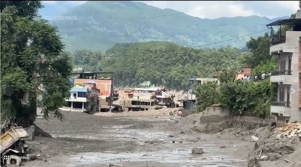
A flash flood came down the Bhotekoshi from Tibet into Rasuwa on 26 August 2026. Here is what is confirmed, what is still unknown, and who to call.
Nepal Police, 10 October 2026, 6:00 pm NPT. Sources
KAVRE: The BP Highway has been completely blocked after a landslide with debris occurred in Roshi Rural Municipality-9, Pinthalibesi.
मुग्लिङ–काठमाडौं सडकखण्ड पहिरोका कारण पूर्ण रूपमा अवरुद्ध भएपछि जिल्ला प्रशासन कार्यालय मकवानपुरले त्रिभुवन राजपथमा सवारी आवागमन व्यवस्थित गर्न नयाँ…
KATHMANDU: The three organisations the Japan Nepal Society (JNS), Tokyo, the JICA Alumni Association of Nepal (JAAN) and the Institution for Suitable…
म्याग्दी– कोरलानाका जोड्ने बेनी–जोमसोम–कोरला सडक मर्मतको काम अन्तिम चरणमा पुगे पनि नियमित, सहज र सुरक्षित यातायात सञ्चालनमा चुनौती देखिएको छ ।
Mudslides and floods disrupted Central Nepal on August 26, 2026, with children being one of the most affected ones. The devastating flood served as an…
10 October 2026, 9:56 am NPT
KAVRE: The BP Highway has been completely blocked after a landslide with debris occurred in Roshi Rural Municipality-9, Pinthalibesi.
Photograph: Nepal News
10 October 2026, 8:20 am NPT
त्रिभुवन राजपथमा सवारी आवागमनको नयाँ समय तालिका लागू
मुग्लिङ–काठमाडौं सडकखण्ड पहिरोका कारण पूर्ण रूपमा अवरुद्ध भएपछि जिल्ला प्रशासन कार्यालय मकवानपुरले त्रिभुवन राजपथमा सवारी आवागमन व्यवस्थित गर्न नयाँ समयतालिका निर्धारण गरेको छ।
Photograph: nagariknews.nagariknetwork.com
9 October 2026, 1:11 pm NPT
Over Rs 3.547 million donation handed over to Minister Dr Wagle
KATHMANDU: The three organisations the Japan Nepal Society (JNS), Tokyo, the JICA Alumni Association of Nepal (JAAN) and the Institution for Suitable Actions for Prosperity (ISAP) have donated total Rs 3,547,536 with the objective of…
Photograph: Nepal News
9 October 2026, 6:57 am NPT
विपद् प्रभावित बेनी-जोमसोम कोरला सडकमा यातायात सञ्चालनमा चुनौती
म्याग्दी– कोरलानाका जोड्ने बेनी–जोमसोम–कोरला सडक मर्मतको काम अन्तिम चरणमा पुगे पनि नियमित, सहज र सुरक्षित यातायात सञ्चालनमा चुनौती देखिएको छ ।
Photograph: Khabarhub
8 October 2026, 8:00 am NPT
Training children and students against future disasters
Mudslides and floods disrupted Central Nepal on August 26, 2026, with children being one of the most affected ones. The devastating flood served as an alarming reminder of Nepal’s evolving disaster scenario.
Photograph: OnlineKhabar English News
8 October 2026, 7:22 am NPT
आईपीयू महासभामा नेपालको आपत्कालीन प्रस्ताव दुईतिहाइ बहुमतले चयन
तान्जानिया– तान्जानियाको अरुसामा जारी अन्तर–संसदीय संघ (आईपीयू) को १५३औँ महासभामा नेपालले प्रस्तुत गरेको जलवायुजन्य विपद्सम्बन्धी आपत्कालीन प्रस्ताव दुईतिहाइ बहुमतसहित चयन भएको छ।
Photograph: Khabarhub
7 October 2026, 11:18 am NPT
Relief materials provided to Bhotekoshi flood hit families
KATHMANDU: Relief materials have been provided to the families at the risk located at Dandagaun of Uttargaya rural municipality-2 in the Bhotekoshi flood-affected Rasuwa district.
Photograph: Nepal News
7 October 2026, 11:18 am NPT
Repairs intensified on flood-damaged Beni-Jomsom-Korala road
Myagdi, October 7 Repair and reconstruction work has been intensified along several sections of the Beni-Jomsom-Korala road under the Kaligandaki Corridor after floods and landslides triggered by heavy rainfall disrupted the route.
Photograph: OnlineKhabar English News
7 October 2026, 11:15 am NPT
Early weather warnings ease paddy harvesting for Kanchanpur farmers
Kanchanpur, October 7 Early weather warnings have made it easier for farmers in Kanchanpur to decide when to harvest paddy and protect their crops from rain and floods.
Photograph: OnlineKhabar English News
6 October 2026, 2:18 pm NPT
World Bank projects Nepal economic growth to slow to 3.7 percent
KATHMANDU: The World Bank has projected that Nepal’s economic growth will slow to 3.7 percent this year due to the devastating floods in Rasuwa.
Photograph: Nepal News
6 October 2026, 7:12 am NPT
अर्थमन्त्री वाग्ले र विश्व बैंक समूहका अध्यक्ष बाङ्गाबीच भेटवार्ता
काठमाडौँ– अर्थमन्त्री डा. स्वर्णिम वाग्ले र विश्व बैंक समूहका अध्यक्ष अजय बाङ्गाबीच द्विपक्षीय भेटवार्ता भएको छ।
Photograph: Khabarhub
6 October 2026, 7:00 am NPT
PM Balen Shah’s UN speech and the missing link in Nepal’s climate response
PM Balen Shah addressing the UN General Assembly. Prime Minister Balendra Shah’s address to the United Nations makes a legitimate case for climate justice, grant-based recovery and stronger Himalayan cooperation.
Photograph: OnlineKhabar English News
5 October 2026, 9:53 am NPT
Chitwan National Park preparing to reopen jeep safari from Friday
Jeep safari is Chitwan National Park’s major cash cow. Photo: Nirmal Dulal Chitawan, October 5 Chitwan National Park is preparing to reopen the jungle safari, which was closed inside the park because of the monsoon, from Friday, October 9.
Photograph: OnlineKhabar English News
5 October 2026, 6:00 am NPT
Why climate security must matter to Nepal’s diplomacy
The state of flood-ravaged Syabrubesi. The Trishuli valley has been a trade and pilgrimage route for centuries, linking Nepal with China. On August 26, it became the path of one of the most devastating mountain disasters in recent years.
Photograph: OnlineKhabar English News
5 October 2026, 5:59 am NPT
म्याग्दीका २६ पहिरो अध्ययन : बेनीको न्युरोडमा बढ्यो जोखिम
पछिल्लोपटक बेनीको न्युरोडमा खसेको पहिरो सक्रिय हुनसक्ने, त्यसमाथि पनि थप जमिन चर्किएर बग्नलाई तयार भएर बसेको हुँदा सावधानी अपनाउन, अल्पकालीन र दीर्घकालीन उपाय अपनाउन अध्ययन टोलीका संयोजक खतिवडाले सुझाव दिए ।
Photograph: Online Khabar
4 October 2026, 8:00 pm NPT updated
Latest reported figures: 1,455 confirmed dead
The confirmed death toll in Nepal has risen to 1,455, from 1,454, Nepal Police reports.
Graphic: figures from Nepal Police
4 October 2026, 10:44 am NPT
Phidim Municipality contributes Rs 4.7 million to disaster relief fund
PANCHTHAR: The Phidim Municipality has deposited Rs 4.7 million into the Prime Minister Disaster Relief Fund to assist the survivors of the recent devastating floods that struck the Bhotekoshi-Trishuli river system.
Photograph: Nepal News
4 October 2026, 10:36 am NPT
Lamichhane Foundation donates over £51,000 for flood relief
London, October 4 The Lamichhane Foundation has donated NPR 1.07 crore (£51,727) to support victims of the recent floods in Nepal’s Bhote Koshi region.
Photograph: OnlineKhabar English News
Updated 10 October 2026, 6:00 pm NPT
01. Confirmed
Confirmed deaths only, both sides of the border. Tap a row for the breakdown.
Rasuwa flash flood, 26 August 2026 · as of 10 October 2026, 6:00 pm NPT · Nepal Police
Tap any number to see where it comes from. Early counts move. Where sources disagree, the lower confirmed figure is shown.
In danger right now? Tap to call.
The flood started in Rasuwa, but the water carried people far downstream. 5,132 people are still listed missing. A district here is where a body was found, not where the person was from.
| District | Bodies recovered |
|---|---|
| Chitwan | 369 |
| Rasuwa | 236 |
| Nawalparasi East | 232 |
| Nawalparasi West | 222 |
| Nuwakot | 205 |
| Gorkha | 80 |
| Dhading | 73 |
| Tanahun | 38 |
Nepal Police bulletin, 4 October 2026, 8:00 pm NPT, totalling 1,455, which is the same total the bulletin itself states. The headline figure above is the same total, from the same count.
Three deaths confirmed near Gyirong (Kyirong) county, just over the border from Rasuwagadhi, where the dry port and customs area were hit. China has said it is reviewing its own flood monitoring for the Kyirong valley.
No deaths of foreign nationals have been confirmed. Syabrubesi is the gateway to the Langtang trek, so trekker whereabouts are being checked through the Tourist Police (1144) and trekking operators.
Updated as new figures are confirmed. Where two sources disagree, the lower confirmed number is shown.
02. Timeline
Pieced together from police, local officials, and news reports. Times are approximate.
Seismic stations picked up a signal near the border. The US Geological Survey first called it a magnitude 4.4 earthquake, then revised it: the signal was a magnitude 5.2 glacial collapse, not a quake.
The Bhotekoshi River suddenly rose at the border. It wasn't raining nearby, so plain rain wasn't the cause.
Timure and Syabrubesi, two border towns, were hit hardest. Nine bank branches were swept away. The local helipad was destroyed, which slowed rescue by air.
The flood reached towns further downstream: Betrawati and Trishuli Bazar, Galchhi and Dhunge Bazaar, then past Muglin into the Narayani. 14 hydropower projects were damaged.
Nepal's Army, Police, and Armed Police are searching for survivors with helicopters. China has confirmed deaths on its side too.
The same figures as the counters at the top of this page, from the same file, so the two cannot disagree. Last moved 10 October 2026, 6:00 pm NPT, from Nepal Police.
| Figure | Count | What the source said |
|---|---|---|
| confirmed dead | 1,455 | Nepal Police: 1,455. Up from 1,454. |
| listed missing in Nepal | 5,132 | NDRRMA, 9 September, 11:00 NPT: about 5,132 people remained unaccounted for. The list remains under verification. |
| missing on the China side | 546 | Xinhua reports 546 people missing around Gyirong Port in Xizang (Tibet) as of 6pm Saturday, including 261 foreign nationals. Combined with Nepal's 2,502-person list that is 3,048 people unaccounted for across both countries, although the two countries' counts may overlap. |
| rescued so far | 13,646 | NDRRMA, 9 September, 11:00 NPT: 13,646 people rescued. |
| hydropower projects damaged | 14 | The Nepal Electricity Authority reports 14 projects damaged with a combined capacity of about 748 MW: 9 operating plants (354 MW) and 5 under construction (394 MW). Named ones include Rasuwagadhi, Chilime, Sanjen Khola, Upper Trishuli-1, Trishuli and Devighat, plus a 220 kV substation. An earlier same-day Ministry of Energy estimate said 431 MW. |
| damage, early estimate | Rs 200bn | Physical Infrastructure Minister Sunil Lamsal put damage to roads and bridges at about Rs 200 billion on 26 August, and called it preliminary. Hydropower and private property are not in that figure. The whole 42 km road from Betrawati to the Rasuwagadhi border crossing was destroyed at multiple points. |
| relief fund deposited | Rs 5.04bn | Prime Minister Balen Shah said Rs 5.04 billion had been deposited in nine commercial bank accounts for flood rescue and relief, Onlinekhabar reported at 9:04pm Saturday. The same report said another US$1.8 million was deposited at Himalayan Bank and Laxmi Bank. This is money deposited in the fund, not the separate Rs 1 billion released by the government. |
Search and rescue is still running, so every number here can change. Tap any counter at the top of the page for the sentence it came from.
03. Cause
No government has confirmed the cause yet. It was not raining nearby, so ordinary rain is ruled out. Best current read, from experts reviewing satellite images:
Nepal's Department of Hydrology and Meteorology and independent glaciologists, using satellite images shared through ICIMOD, say an ice-and-rock avalanche blocked the Lhende Khola about 20 km upstream of the Miteri Bridge. That made a temporary lake behind the debris, which then burst. They call it preliminary.
A lake of meltwater held back by ice can break free on its own, with no rain. Over 20 lakes in Nepal are rated dangerous, and many more sit unmonitored across the border.
The US Geological Survey first logged a magnitude 4.4 earthquake at 08:37, minutes before the water rose. It has since revised that: the signal was a magnitude 5.2 glacial collapse, not a tectonic quake. The tremor was the collapse being recorded, not a separate trigger.
The Lende Khola (Lhende) valley in Kyirong county, Tibet, upstream of Rasuwagadhi. Photos are openly licensed, pulled live from Wikimedia Commons with credit.
Map centred near the suspected landslide site, about 20 km north of the border inside Tibet. Exact coordinates are approximate, from published reporting.
04. Questions
The things people are searching for most, answered short.
On the morning of 26 August 2026 a flash flood came down the Bhote Koshi river from the Tibet side of the border into Rasuwa district. Timure, Syabrubesi, the Rasuwagadhi border crossing and around a dozen riverside settlements took the heaviest impact, and the water carried on down the Trishuli into the Narayani. The Nepal Electricity Authority reports 14 hydropower projects damaged, about 748 MW.
No government has confirmed a cause. The leading explanation, from Nepal's Department of Hydrology and Meteorology and independent glaciologists working with satellite imagery shared through ICIMOD, is an ice-and-rock avalanche that blocked the Lhende Khola inside Tibet about 20 km upstream of the Miteri Bridge, forming a temporary debris-dammed lake that then burst. The US Geological Survey has reassessed the tremor recorded minutes earlier as a magnitude 5.2 glacial collapse, not an earthquake. Heavy local rainfall in Rasuwa is ruled out. Full explanation.
Rasuwa took the first and heaviest impact, especially Timure, Syabrubesi and the Rasuwagadhi border crossing. The surge then moved through Betrawati and Trishuli Bazar in Nuwakot, Galchhi and Dhunge Bazaar in Dhading, and past Muglin into the Narayani. Bodies have been recovered in Chitwan, Nawalparasi East and West, Gorkha and Tanahun as well. Three deaths are confirmed on the Chinese side near Gyirong.
Kathmandu itself was not flooded. The damage runs along the Bhotekoshi and Trishuli river valleys in Rasuwa and Nuwakot districts, north-west of the capital. Road links to the Chinese border through Rasuwagadhi have been badly disrupted.
Nepal Police 100, ambulance 102, fire brigade 101, traffic police 103, and 112 from any mobile phone. The National Emergency Operation Centre disaster hotline is 1149, the Nepal Police toll-free helpline is 1155, and Tourist Police is 1144. All of them are tap-to-dial on the Emergency tab.
The Government of Nepal's own channel is the Prime Minister's Natural Disaster Relief Fund, run by the Office of the Prime Minister. Bank account details and the official QR code are on the Help tab. Be careful of fake appeals, which appear within hours of any disaster.
Syabrubesi is the main gateway to Langtang trekking and was directly hit, including the loss of its helipad. Roads along the river valley have been damaged. Check with Nepal Police, the Tourist Police on 1144, and your trekking operator before travelling.
Today · Nepal + world
10 October 2026, 9:56 am NPT
KAVRE: The BP Highway has been completely blocked after a landslide with debris occurred in Roshi Rural Municipality-9, Pinthalibesi.
Photograph: Nepal News
10 October 2026, 8:20 am NPT
त्रिभुवन राजपथमा सवारी आवागमनको नयाँ समय तालिका लागू
मुग्लिङ–काठमाडौं सडकखण्ड पहिरोका कारण पूर्ण रूपमा अवरुद्ध भएपछि जिल्ला प्रशासन कार्यालय मकवानपुरले त्रिभुवन राजपथमा सवारी आवागमन व्यवस्थित गर्न नयाँ समयतालिका निर्धारण गरेको छ।
Photograph: nagariknews.nagariknetwork.com
9 October 2026, 1:11 pm NPT
Over Rs 3.547 million donation handed over to Minister Dr Wagle
KATHMANDU: The three organisations the Japan Nepal Society (JNS), Tokyo, the JICA Alumni Association of Nepal (JAAN) and the Institution for Suitable Actions for Prosperity (ISAP) have donated total Rs 3,547,536 with the objective of…
Photograph: Nepal News
9 October 2026, 6:57 am NPT
विपद् प्रभावित बेनी-जोमसोम कोरला सडकमा यातायात सञ्चालनमा चुनौती
म्याग्दी– कोरलानाका जोड्ने बेनी–जोमसोम–कोरला सडक मर्मतको काम अन्तिम चरणमा पुगे पनि नियमित, सहज र सुरक्षित यातायात सञ्चालनमा चुनौती देखिएको छ ।
Photograph: Khabarhub
8 October 2026, 8:00 am NPT
Training children and students against future disasters
Mudslides and floods disrupted Central Nepal on August 26, 2026, with children being one of the most affected ones. The devastating flood served as an alarming reminder of Nepal’s evolving disaster scenario.
Photograph: OnlineKhabar English News
8 October 2026, 7:22 am NPT
आईपीयू महासभामा नेपालको आपत्कालीन प्रस्ताव दुईतिहाइ बहुमतले चयन
तान्जानिया– तान्जानियाको अरुसामा जारी अन्तर–संसदीय संघ (आईपीयू) को १५३औँ महासभामा नेपालले प्रस्तुत गरेको जलवायुजन्य विपद्सम्बन्धी आपत्कालीन प्रस्ताव दुईतिहाइ बहुमतसहित चयन भएको छ।
Photograph: Khabarhub
7 October 2026, 11:18 am NPT
Relief materials provided to Bhotekoshi flood hit families
KATHMANDU: Relief materials have been provided to the families at the risk located at Dandagaun of Uttargaya rural municipality-2 in the Bhotekoshi flood-affected Rasuwa district.
Photograph: Nepal News
7 October 2026, 11:18 am NPT
Repairs intensified on flood-damaged Beni-Jomsom-Korala road
Myagdi, October 7 Repair and reconstruction work has been intensified along several sections of the Beni-Jomsom-Korala road under the Kaligandaki Corridor after floods and landslides triggered by heavy rainfall disrupted the route.
Photograph: OnlineKhabar English News
7 October 2026, 11:15 am NPT
Early weather warnings ease paddy harvesting for Kanchanpur farmers
Kanchanpur, October 7 Early weather warnings have made it easier for farmers in Kanchanpur to decide when to harvest paddy and protect their crops from rain and floods.
Photograph: OnlineKhabar English News
6 October 2026, 2:18 pm NPT
World Bank projects Nepal economic growth to slow to 3.7 percent
KATHMANDU: The World Bank has projected that Nepal’s economic growth will slow to 3.7 percent this year due to the devastating floods in Rasuwa.
Photograph: Nepal News
6 October 2026, 7:12 am NPT
अर्थमन्त्री वाग्ले र विश्व बैंक समूहका अध्यक्ष बाङ्गाबीच भेटवार्ता
काठमाडौँ– अर्थमन्त्री डा. स्वर्णिम वाग्ले र विश्व बैंक समूहका अध्यक्ष अजय बाङ्गाबीच द्विपक्षीय भेटवार्ता भएको छ।
Photograph: Khabarhub
6 October 2026, 7:00 am NPT
PM Balen Shah’s UN speech and the missing link in Nepal’s climate response
PM Balen Shah addressing the UN General Assembly. Prime Minister Balendra Shah’s address to the United Nations makes a legitimate case for climate justice, grant-based recovery and stronger Himalayan cooperation.
Photograph: OnlineKhabar English News
5 October 2026, 9:53 am NPT
Chitwan National Park preparing to reopen jeep safari from Friday
Jeep safari is Chitwan National Park’s major cash cow. Photo: Nirmal Dulal Chitawan, October 5 Chitwan National Park is preparing to reopen the jungle safari, which was closed inside the park because of the monsoon, from Friday, October 9.
Photograph: OnlineKhabar English News
5 October 2026, 6:00 am NPT
Why climate security must matter to Nepal’s diplomacy
The state of flood-ravaged Syabrubesi. The Trishuli valley has been a trade and pilgrimage route for centuries, linking Nepal with China. On August 26, it became the path of one of the most devastating mountain disasters in recent years.
Photograph: OnlineKhabar English News
5 October 2026, 5:59 am NPT
म्याग्दीका २६ पहिरो अध्ययन : बेनीको न्युरोडमा बढ्यो जोखिम
पछिल्लोपटक बेनीको न्युरोडमा खसेको पहिरो सक्रिय हुनसक्ने, त्यसमाथि पनि थप जमिन चर्किएर बग्नलाई तयार भएर बसेको हुँदा सावधानी अपनाउन, अल्पकालीन र दीर्घकालीन उपाय अपनाउन अध्ययन टोलीका संयोजक खतिवडाले सुझाव दिए ।
Photograph: Online Khabar
4 October 2026, 8:00 pm NPT updated
Latest reported figures: 1,455 confirmed dead
The confirmed death toll in Nepal has risen to 1,455, from 1,454, Nepal Police reports.
Graphic: figures from Nepal Police
4 October 2026, 10:44 am NPT
Phidim Municipality contributes Rs 4.7 million to disaster relief fund
PANCHTHAR: The Phidim Municipality has deposited Rs 4.7 million into the Prime Minister Disaster Relief Fund to assist the survivors of the recent devastating floods that struck the Bhotekoshi-Trishuli river system.
Photograph: Nepal News
4 October 2026, 10:36 am NPT
Lamichhane Foundation donates over £51,000 for flood relief
London, October 4 The Lamichhane Foundation has donated NPR 1.07 crore (£51,727) to support victims of the recent floods in Nepal’s Bhote Koshi region.
Photograph: OnlineKhabar English News
Updated 10 October 2026, 6:00 pm NPT
Official
The feed below refreshes on its own. UN disaster alerts, the US Geological Survey earthquake service, and named newsrooms, pulled through this site's own server. Each card is a headline and a link, so you read the story at the source.
The written summaries further down are checked by a person. This feed is not. Where they disagree, trust the source link.
Death and damage counts are still being confirmed. Six power stations damaged so far.
Army, Police, and Armed Police searching by helicopter where landing is still possible.
China confirms deaths on its side, near Gyirong. Reviewing its own flood monitoring.
Official bulletins, rewritten short. The source sits beside each one so you can read the original.
Search and rescue is running in Rasuwa and Nuwakot. Army, Police and Armed Police teams are working the river corridor, with helicopters used where they can still land.
Read NDRRMA's own bulletins ↗Missing-person reports are being taken at district police offices. Families are asked to give a full name, age, last known location and what the person was wearing.
Read Nepal Police posts ↗The Prime Minister's Natural Disaster Relief Fund is the government's own channel for donations towards rescue and rebuilding. Bank details are on the Help tab.
Office of the Prime Minister ↗The flood came down the Bhotekoshi from the Tibet side on a morning with no rain nearby. Experts studying satellite images point to a mass of ice and rock that dammed a mountain stream and then gave way. No government has confirmed a cause yet.
See the full source listEvery incident recorded nationwide in the last three weeks, from BIPAD, the government's own disaster portal. Floods, landslides, fires, all of it. A record, not a news summary.
From UN OCHA's ReliefWeb and GDACS, refreshed automatically. Agency Facebook pages are linked below.
Official channels, straight from the response:
Three things about this valley that decided how bad it got
The river drops about 3,000 metres in under 40 km, one of the steepest drops in the Himalaya. Water from a burst upstream can reach a village in under an hour. Almost no time to run.
Above the join it is called Bhotekoshi. Below it, Trishuli. Same water. In Tibet the upper river is the Kyirong Tsangpo, fed by the Lende Khola, where the ice and rock came down.
A broadly similar flood hit this same river in July 2025, traced to a lake draining off the surface of a glacier. Hydropower on this corridor has now been damaged twice in just over a year.
Highest first, with what was hit at each one
| Place | Elevation | What happened |
|---|---|---|
| Lende Khola, Tibet | ~5,000 m | Suspected ice and rock landslide that dammed, then released, the stream. |
| Rasuwagadhi / Gyirong | ~1,850 m | Border crossing. Customs and the dry port were hit on both sides. |
| Timure | ~1,900 m | Border town. Hit first and hardest. Bank branches and customs post swept away. |
| Syabrubesi | ~1,470 m | Helipad destroyed, which slowed rescue flights. Bhotekoshi meets the Trishuli here. |
| Betrawati | ~730 m | Flood reached here further downstream, still moving fast. |
| Devighat | ~460 m | Furthest downstream site hit. Hydropower station damaged. |
Rasuwa · Bhote Koshi · Trishuli
List under verification
NDRRMA ↗Rasuwa · Nuwakot · Dhading
Roads, bridges and hydropower facilities damaged.
Current road notices ↗Check open routes and limits before travelling.
Source ↗View mapped damage by location.
Copernicus maps ↗Act now
Call, search, report or give. Each link opens the service that handles it.
100Nepal Police, from any phone In immediate danger, call first. Everything else on this tab can wait.

Emergency
Tap any number below to dial it. These are national numbers and work from any phone in Nepal. From a mobile, 112 also reaches emergency services.
100 / 101 / 102 / 103 / 112 confirmed against the public emergency-number register. 1149, 1155 and 1144 are the published hotlines of the National Emergency Operation Centre and Nepal Police. If a line is busy, try 100 or 112.
Numbers below the national ones change by district and by hospital, so this links to the official directories that publish them rather than printing digits that may be out of date. Every link is a government or Red Cross page.
Call the nearest District Police Office or 100. Give full name, age, last known location, and what they were wearing.
Register the same details with the local ward office, they hold the evacuation and shelter lists.
If the person may have crossed into China at Rasuwagadhi, tell the police that specifically. Cross-border checks are handled separately.
Keep one phone number reachable and charged. Rescue teams call back, often from an unknown number.
Contact your own country's embassy in Kathmandu first, they coordinate directly with Nepal Police on foreign nationals. The Department of Immigration holds entry records that help confirm whether someone entered the district.
Straight from the US Geological Survey, updated automatically. Aftershocks and new quakes in the Nepal region appear here first.
Give
Every link goes to Nepal's own government fund. This site never handles your money.
Nepal's own government fund for disaster rescue and rebuilding. The only place this page recommends. Bank details below are transcribed from the Prime Minister's Office's own graphic.
The government opened its own online donation gateway on 27 August 2026: pmdrf.nchl.com.np. Run by Nepal Clearing House for the Office of the Prime Minister. International and Nepali cards, NepalPay QR, connectIPS, mobile banking and wallets. You are charged in Nepali rupees, so your own bank sets the exchange rate.
This is the only payment link on this site, and it is here because the Office of the Prime Minister published it itself. The older address pmrelief.opmcm.gov.np still does not load, checked 28 Aug 2026.
| Bank | Account |
|---|---|
| Himalayan Bank (USD account) | 01905631210046 |
| Standard Chartered Bank Nepal | 01013243801 02013243801 |
| Rastriya Banijya Bank | 1130100003762001 1130100000006006 |
| Everest Bank | 00100105200270 00101102200012 |
| Nepal Bank | 00211600510039000003 00200100510039000001 |
| Global IME Bank | 00401010000057 00411010000005 |
| Nabil Bank | 1710017505285 |
| Agricultural Development Bank | 0100201002907014 |
Prime Minister's Relief Fund (general, not disaster-specific):
| Bank | Account |
|---|---|
| Rastriya Banijya Bank | 1430100000025006 1430100001164001 |
Official QR, from PMO Nepal directly.
Blood is needed after any disaster; the Nepal Red Cross runs collection across Kathmandu. Verified local photos, missing-person details and shelter reports also help, they are what response teams work from.
Fake relief appeals appear within hours of every disaster. Check the account name matches a registered organisation, be suspicious of personal wallets, and never send money because a message says the deadline is tonight.
Learn
Nepal sits where two continents collide, under monsoon rain and below melting ice. Five hazards come out of that. Which one you are facing changes what you should do.
High in the mountains, melting glaciers leave lakes behind. The wall holding one back is often just loose rock and ice. When it fails, the whole lake leaves at once and races down the valley as a wall of water, mud, and boulders.
Warning signs: the river suddenly rises or suddenly stops, on a day with no rain. A roar from upstream. Water turning grey or brown.
What to do: go uphill, away from the river, immediately. Not along the road, roads follow rivers. You may have minutes, not hours.
Nepal's exposure: more than 20 glacial lakes are classified as potentially dangerous, and many more sit across the border in Tibet where Nepal has no monitoring.
India is pushing under Asia at about 2 cm a year. That strain releases as earthquakes. The 2015 Gorkha earthquake killed nearly 9,000 people.
What to do during shaking: drop, cover, hold on. Get under a sturdy table, away from windows. Do not run outside mid-shake, falling masonry is the main killer.
After: expect aftershocks. Avoid damaged buildings, steep slopes and riverbanks, a quake loosens both.
Steep slopes plus heavy rain plus cut roads equals landslides. They cause a large share of Nepal's monsoon deaths every year, usually at night, usually with no warning.
Warning signs: new cracks in the ground or in walls, doors and windows suddenly sticking, tilting trees or poles, a rumbling that grows.
What to do: move sideways off the slope path, not straight downhill. If indoors on a slope at night in heavy rain, sleep on the uphill side of the house.
June to September brings most of Nepal's yearly rain. In the Tarai plains, rivers spread out slowly over days; in the hills they rise in hours.
What to do: never walk or drive into moving water. Thirty centimetres will float a car, fifteen will knock an adult over. Turn around.
Watch: the BIPAD portal publishes live river gauge levels for major rivers.
Less talked about, still deadly. Lightning kills around 100 people a year in Nepal. Dry-season fires spread fast through village housing; winter cold waves hit the Tarai hardest.
Lightning rule: when you hear thunder within 30 seconds of a flash, go inside for 30 minutes after the last thunder. Not under a lone tree.
Know a route uphill, not along the road. Roads follow rivers, and they flood first.
Loud river noise, or water rising with no rain, is the warning. Move first, ask questions later.
Keep ID, cash, medicines and a torch in one bag you can grab in the dark.
Pick a family meeting spot above the flood line. Phones stop working first.
If you run a shop or homestay by the river, plan to lose the ground floor. Know what's load-bearing.
Save the emergency numbers on the next tab into your phone now, not during the emergency.
A burst lake can reach a village in under an hour. Some Nepali lakes now have sensors and sirens. Most, especially those across the border, do not, so the first warning is often the sound of the river itself.
Himalayan ice is melting faster than it is replaced. More meltwater means more and bigger lakes held back by weaker walls, in valleys where more people now live and build than a generation ago.
Learn more from the people who study this:
Sources
If something here is not traceable to one of these, it should not be here. Tell us and we will pull it.
Wikipedia, 2026 Nepal floods
CNN live coverage
NPR
US News (Reuters)
Al Jazeera
The Week
Kathmandu Post
India TV News, satellite image analysis
GDACS, the UN and European Commission disaster alert system.
USGS earthquake service, public domain.
ReliefWeb, UN OCHA humanitarian reporting.
Wikimedia Commons, for the openly licensed photos and video.
Satellite imagery © Esri, Maxar, Earthstar Geographics and the GIS user community, used under Esri's attribution terms.
Terrain from OpenTopoMap (CC-BY-SA).
Street map data © OpenStreetMap contributors.
Place links open in Google Maps in a new tab; no Google imagery is copied onto this page.


